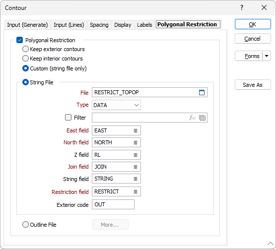
Polygonal Restriction
On the Polygonal Restriction tab of the Load Contours form, select the Polygonal Restriction check box option to restrict the data that is displayed by applying polygonal (string or outline) restrictions.
Keep exterior contours
If the Keep exterior contours option is selected, the process will keep the contours that fall outside the polygons or the outlines in the Restriction file.
Keep interior contours
If the Keep interior contours option is selected, the process will keep the contours that lie within the polygons or the outlines in the Restriction file.
Custom (String file only)
When setting polygonal restrictions with a String file, it is possible to apply Custom Restrictions.
When polygonal restrictions are applied, the codes in a Restriction field are compared with an Exterior code you have entered. If the entered value and the code values in the field match, exterior contours are kept. If the code values in the field do not match, interior contours are kept.
When applying custom restrictions, the order of the polygons in the file is important. The polygons in the file are processed sequentially. Those polygons that have the same contiguous Code values are processed as a batch.
If the polygons used to set polygonal restrictions overlap, a union of the polygons is used to remove the overlaps.
Use the Apply button to preview the result of your custom restrictions.
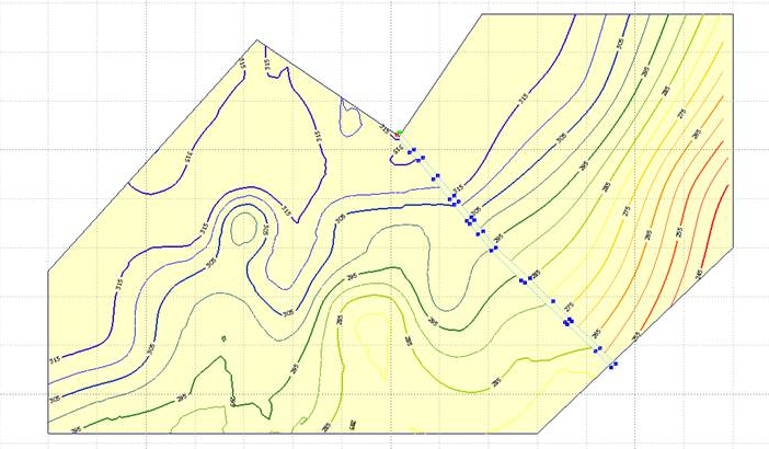
The contours below are the roof elevations of a seam.
The outer polygon is a tenement (mining lease) boundary and we are not interested in anything outside this area (Keep Interior).
The highlighted string represents the region around a fault line, and we can see that the contours are “disrupted” by the fault.
Contours in the fault (no coal) zone are meaningless (Keep Exterior).
String File
File
Select a file Type and then double-click (F3) to select the input File that contains the polygons you want to use to restrict the data. Optionally, apply a Filter to limit the records to a particular subset of data.
East. North, Z fields
Double-click (F3) to specify the names of the fields in which Easting and Northing and Z coordinates are stored.
String field
(Optional) Specify the name of the field containing values which define whether data points will be joined by a line. The values of this field in successive records must be the same before the points will be strung.
Join field
Specify the name of the field containing values which define whether data points will be joined by a line i.e. strung. If successive records have the same value in this field and no String field is defined a line will join the points. If a String field is defined, then values in each field in successive records must be the same before the points will be strung.
Restriction field
If you have chosen the Custom restriction option for a String file, select a field which contains the values that denote whether interior or exterior contours should be kept.
Exterior code
If you have specified a Restriction field, you must also enter a code value that can be used by the process to interrogate the values in the Restriction field.
Outline File
Select the Outline File option to set outline restrictions to control what is shown in the Contours display. Click the More button to open the Outline Restrictions dialog.