Polygonal Model
Alternatively, on the Block Model tab, in the Polygonal Estimate group , click New/Load Model.
![]()
The polygons for interpretation should be 2D polygons. It is assumed that the drillholes fall exactly on the plane of each section. Click Flatten Drillholes to Section to flatten the holes in a drillhole database and save a copy of the flattened database. You can also use the Tolerance parameter in the Polygonal Model form, to include off-section assay intervals.
For more information refer to the Polygonal Estimation topic.
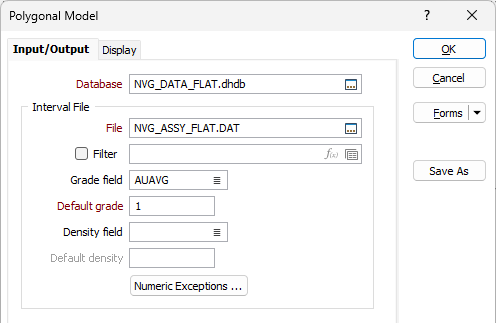
Input/Output
On the Input/Output tab of the Polygonal Model form, specify a flattened drillhole database and a file containing the polygons you will use for the interpolation.
Database
Double-click (or click on the Select icon) to select from a list of drillhole databases in the current project.
Tip: Press F5 to create a new drillhole database. Press F4 to edit a drillhole database you have selected.
Interval file
File
Double-click (or click on the List icon) to select the Interval file that will be used as input to the process. There are four possible scenarios when it comes to reporting grade, density, tonnage, and metal:
| GRADE field | DENSITY field | Report Output |
|---|---|---|
|
Yes |
Yes |
GRADE, DENSITY, TONNAGE, METAL |
|
Not defined |
Not defined |
- |
|
Yes |
Not defined |
GRADE |
|
Not defined |
Yes |
DENSITY and TONNAGE |
Numeric Exceptions
(Optionally) Use the Numeric Exceptions group to control the way that non-numeric values are handled. Non-numeric values include characters, blanks, and values preceded by a less than sign (<).
Grade field
If there is a Grade field in the Input file, double-click (or click on the List icon) to select the name of the field that contain the Grade values that will be used in the grade tonnage calculation.
Default Grade
Enter a default Grade value. If a Grade value is missing when a record is processed the default Grade value will be used in its place.
Density field
If there is a Density field in the Input file, double-click (or click on the List icon) to select the name of the field that contain the Density values that will be used in the grade tonnage calculation.
Default Density
Enter a default Density value. If a Density value is missing when a record is processed the default Density value will be used in its place.
Polygons
File
Select a file type (typically a String file) and then double-click (or click on the List icon) to select the file that contains the interpretation polygons.
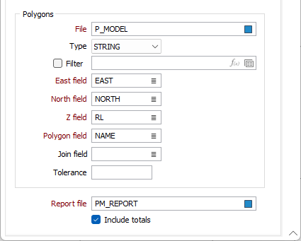
Easting, Northing and Z fields
Double-click (or click on the List icon) to select the coordinate fields in the Input file.
Polygon field
The polygon name from the Polygon field is used to name the respective polygons in the Report file. The Polygon field is treated as a String field when loading the polygons.
To be able to close to a line or to a point, the ‘closure’ lines or points must be contained within the Polygons file.
Join field
Specify the name of the field containing values which define whether data points in the Polygons file are joined by a line i.e. strung. If successive records have the same value in this field, a line will join the points.
Tolerance
All drillholes are assumed to fall exactly on the plane of each section, and theoretically there is no need to define a section corridor or tolerance when selecting assay intervals for the length-weighted average. Some tolerance should be provided, however, to ensure that all assays on each plane are included.
The Tolerance value is expressed in Grid units. The default value is 1E-06. If no value is supplied, it is assumed that the drillhole trace is sitting on the section line. By default, a point on the trace will be excluded if it is further than 0.000001 grid units off the section.
Report file
Double-click (or click on the Select icon) to select the name of the file where the results of the calculation will be written. Select the Include totals check box option to write the following totals to the Report file:
| Field | Report Output |
|---|---|
|
POLYGON 1 |
No value, include the word TOTAL. |
|
POLYGON 2 |
No value. |
|
POLYGON 1 AREA |
The sum of all Polygon 1 areas. |
|
POLYGON 2 AREA |
The sum of all Polygon 2 areas. |
|
POLYGON 1 GRADE |
The average (arithmetic mean) of all Polygon 1 grade values. |
|
POLYGON 2 GRADE |
The average of all Polygon 2 grade values. |
|
VOLUME |
The sum of all volume values. |
|
GRADE |
The average of all grade values. |
|
DENSITY |
The average of all density values. |
|
TONNAGE |
The sum of all tonnage values. |
|
METAL |
The sum of all metal values. |
Complete the configuration on the Display tab.
Forms
Click the Forms button to select and open a saved form set, or if a form set has been loaded, save the current form set.
Run
Enter parameters in the form, then click Run to run the function.