Assign Elevation
On the Design tab, in the Editing group, Click More… ![]() and select Assign Elevation to interactively set the elevation of selected strings in Plan view using a Direction string. The direction of the string (from its start point to its end point) determines the order (first, second, third etc.) in which the Target strings are assigned an incremental elevation.
and select Assign Elevation to interactively set the elevation of selected strings in Plan view using a Direction string. The direction of the string (from its start point to its end point) determines the order (first, second, third etc.) in which the Target strings are assigned an incremental elevation.
If you are assigning elevations to an existing String layer, the Input file must have a field in which to store the assigned elevation values. In the case of a new layer, this field is created and populated automatically.
![]()
As a prerequisite to using the function you should know the trend of the contour strings (typically) and the required increment between them.
To assign elevations to strings in Vizex:
- Define a Z field in the file where the elevations are to be assigned (in the target String file).
- Populate the Z field with some suitable constant.
- Display the String layer using the constant Z value field.
This needs to be populated because if the Z values are blank those strings will not be displayed.
- Add a (temporary) new String layer and digitise the Direction strings (typically) or open a String layer that contains the Direction strings.
- On the Design tab, in the Editing group, select More | Assign Elevation.
- If no strings are selected, the Selection Assistant will prompt you to select the Direction strings (the strings that determine the order in which the Target strings are assigned):
You can use the mouse with the CTRL or the SHIFT key to select multiple strings.
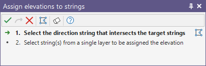
Alternatively, you can Digitise the required object/s using the button in the Selection Assistant toolbar. The Selection Assistant will close, providing access to the tools used to create the object.
-
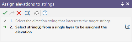
 Click the Accept button, then use the mouse to select the strings that will be assigned an incremental elevation
The Target strings you select must belong to the same layer.
-
Click the Accept button to open the Assign Elevation dialog.
- Set the value of the Start elevation and an elevation Increment
- Double-click to select the Elevation field (or in the case of a new layer, accept the default).
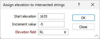
- Finally, click OK to assign elevations to the selected strings.
The first Target string that intersects a Direction string is assigned the Start elevation. Subsequent strings are assigned elevation values which are incremented using the specified Increment value.