Load Drillholes into Plan
![]()
There are two input methods:
-
From Drillhole Database
-
From Trace String File
Note that you can use either method or use both.
From Drillhole Database
Select this check box to load the drillholes in a Drillhole Database.
Name
Double-click (F3) to select the name of the database containing your data. Optionally, apply a filter to limit what data is displayed. See: Filter
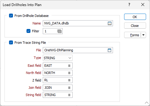
From Trace String File
Select a file Type and then double-click (F3) to select the input File that contains the trace strings you want to load into the plan.
East and North and Z fields
Specify the names of the fields in which Easting, Northing, and Z coordinates are stored in the String file.
Join field
In forms that require polylines as an input, the values in this field define whether the data points in the input file should be joined by a line. If successive records have the same value in this field, a line will join the points. If two-factor topology is required, the values in a String field may also be used to segment the lines.
String field
In most forms, the String field is an optional generic attribute used to store a secondary input such as a code. Traditionally, this field has also been used with the Join field to define whether data points should be joined by a line, or strung, hence the name.