Vein
The Vein lithology model can be generated using Strings and/or Structural Data Input data.
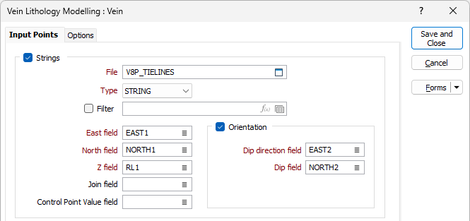
Strings
If you select the Input Data option and the Strings check box, you can select and configure a String file for the lithology model.
Select a File and Type for the String, and optionally select or create a Filter (or click the icon to open the Expression Editor and use an expression).
East, North and Z
Double-click to select the names of the fields that define the coordinates of the model in the String file.
Join
Optionally, enter (or double-click to select) the name of the Join fields in the file. The Join field contains values that define whether data points will be joined by a line i.e. strung.
Control Point Value field
Optionally, select the field in the string file where the control point value is stored. If a field name is specified, the value contained in the field will determine the behaviour of the Vein model:
-
Positive values (+1) will modify the hanging wall surface of the Vein model.
-
Negative values (-1) modify the footwall surface of the Vein model.
-
Zero (0) values represent pinch points in the model, which forces the application to pinch the Vein at that point.
-
If the field value is left BLANK for individual records in the input DAT file, then those input points will not control the location of the Vein surfaces.
Orientation
If you select the Orientation check box, you can select the Dip direction field and Dip field for the lithology model from the String file.
For points on the boundary (Control Point Value = +1 or -1) of the model, the Orientation values specify the dip and dip directions of the surface of the model, otherwise Orientation specifies the trend of the model.
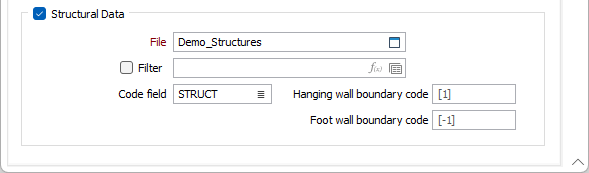
Structural Data
You can select the Structural Data check box in combination with the Strings check box, or as the only option.
If the check box is selected, select a structural data File from the field and optionally add a Filter.
Double click in the Code field or use the list button to select the field in the file that contains the Code for the structural data. Codes in the structural data file can be used to specify whether a structural data point also defines the boundary of the lithology model, or only the trend of the model.
If you enter a code in the Code field, then only structural data points whose associated Code values matches that specified in the Boundary code field (or Hanging wall boundary and Foot wall boundary where applicable) are modelled as points on the model boundary. The default Boundary code value is 0. Hanging wall boundary and Foot wall boundary fields have default values of +1 and -1 respectively.
If no value is entered for the Code field, which is the default, all structural data points are assumed to have a value of 0, which mean they represent points on the mid vein surface.
When you have specified the required details on the Input tab, click the Options tab to continue.