Compass Traverse
Field exploration surveys are normally carried out by traversing from a known point across country, with a tape and compass or similar instrumentation. The angles and distances between turning points on the traverse are recorded and then used to calculate the coordinates of the turning points.
![]()
Compass traverses may include shots (bearings and distances) to points to the side of the main traverse line, these are called radial points. The Compass Traverse function works with any sets of measurements that have:
- Horizontal angles measured from north.
- Vertical angles to record the inclination or declination to an observed point.
- Slope (or horizontal) distances.
There are two modes:
- Calculations without a Station file: the traverse file must contain coordinates (and RL if used) for the starting point of each traverse.
- Calculations with a Station file: the starting point of a traverse may be referenced to a station (or the coordinates may be specified). Also, a point in one traverse may be used to calculate a new station for use in a subsequent traverse, and will be added to the Station file. If a station is specified for a closing point, you can choose to calculate the misclose and optionally adjust the traverse.
The Process
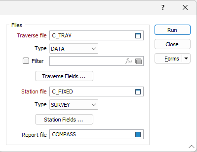
- On the Survey tab, in the Traverse group, click Compass Traverse.
- In the Compass Traverse form, enter the name of the Traverse (input) file. This may contain multiple traverses identified by values in a field.
- Click on Traverse Fields and enter the field names.
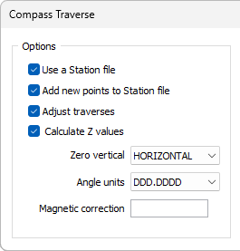
- (Optional) Check the Use a Station file box if you want to reference stations from the traverse file.
- (Optional) Check the Calculate Z values? box if your traverse file contains inclinations and you want to calculate RLs. If so, the tape distances will be read as slope distances and converted to horizontal distances for the calculation of coordinates.
- (Optional) If you checked the Calculate Z values? box, choose the Zero vertical. ZENITH means that 90º or 270º is horizontal; <90º or >270º is an elevation and >90º or <270º is a depression. HORIZONTAL means that 0º is horizontal, positive values are elevations and negative values are depressions.
- Choose the angle units.
- (Optional) Enter a magnetic correction value. This should be the angle between true and magnetic North.
- Run the function. If you chose to adjust traverses, a dialog box will appear for each fixed point (other than the first point of a traverse) showing the misclose, as in the following example:
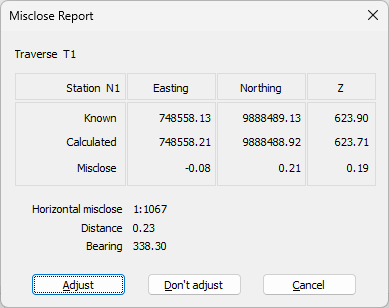
Click Adjust to write adjusted coordinates to the traverse file, and to the report file, if specified.
Click Don't adjust to write unadjusted coordinates to the traverse file, and to the report file, if specified.