General
![]()
The key steps involved in using the Manual Calculations function are as follows:
- In the Manual Calculation General form, choose the angle units.
- Choose the zero vertical. Zenith means that 90 or 270 is horizontal; <90 or >270 is an elevation and >90 or <270 is a depression. Horizontal means that 0 is horizontal, positive values are elevations and negative values are depressions.
- Choose the calculation method.
- (Optional) Enter a report file name.
- Either:
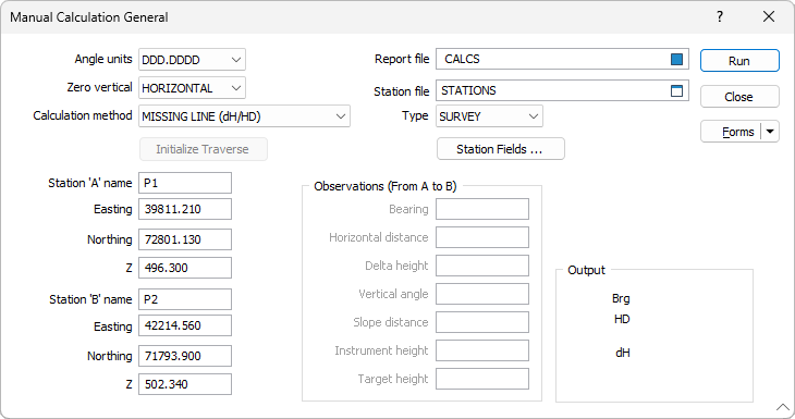
- Enter a Station file name and enter the station field name(s), or
- Type in the station values.
- Run the function to see the displayed output, and generate a report file if you entered a file name.
Missing Line (Height Difference/Horizontal Distance)
This calculates the bearing, horizontal distance and height difference between two stations or points. Do one of the following and run the function:
- Enter the Station file name and field names, and enter the names of the two stations you want to use (Station A and Station B). The coordinates and Z values will be read from the Station file, or
- Enter the coordinates and Z values for two points (Station A and Station B). No station names are necessary.
Missing Line (Vertical Angle and Slope Distance)
This calculates the bearing, slope distance and vertical angle between two stations or points. Do one of the following and run the function:
- Enter the Station file name and field names, plus the names of the two stations you want to use (Station A and Station B). The coordinates and Z values will be read from the Station file, or
- Enter the coordinates and Z values for two points (Station A and Station B). No station names are necessary.
Radiation (Height Difference and Horizontal Distance)
This calculates the Easting, Northing and Z of a point, given the bearing, horizontal distance and height distance from a known station or point. Do one of the following and run the function:
- Enter the Station file name and field names, and the name of the known station (Station A). Enter the bearing, horizontal distance and height difference to the point to be determined, or
- Enter the Easting, Northing and Z of the known point (Station A). No station name is needed. Enter the bearing, horizontal distance and height difference to the point to be determined.
Radiation (Vertical Angle and Slope Distance)
This calculates the Easting, Northing and Z of a point, given the vertical angle, slope distance, instrument height and target height from a known station or point. Do one of the following and run the function:
- Enter the Station file name and field names, and the name of the known station (Station A). Enter the vertical angle, slope distance, instrument height and target height, or
- Enter the Easting, Northing and Z of the known point (Station A). No station name is needed. Enter the vertical angle, slope distance, instrument height and target height.
Traverse (Height Difference and Horizontal Difference)
This calculates the difference in Easting and Northing between two points, and accumulates these values. The sum should be zero at the end of the traverse. You can nominate successive stations from a Station file, or you can manually enter the coordinates of each point in turn. Do one of the following:
- Enter the Station file name and field names and the name of the first station (Station A). Enter the bearing, horizontal distance and height difference, Run the function, then repeat the above for the remaining stations in the traverse, or
- Enter the Easting, Northing and Z for the first point (Station A). No station name is needed. Enter the bearing, horizontal distance and height difference, Run the function, then repeat the above for the remaining stations in the traverse. The station A name field will start at 1 and increment for each point traversed.
Traverse (Vertical Angle and Slope Distance)
This calculates the difference in Easting and Northing between two points, and accumulates these values. The sum should be zero at the end of the traverse. You can nominate successive stations from a Station file, or you can manually enter the coordinates of each point in turn. Do one of the following:
- Enter the Station file name and field names and the name of the first station (Station A). Enter the vertical angle, slope distance, instrument height and target height, Run the function, then repeat the above for the remaining stations in the traverse, or
- Enter the Easting, Northing and Z for the first point (Station A). No station name is needed. Enter the vertical angle, slope distance, instrument height and target height, Run the function, then repeat the above for the remaining stations in the traverse. The station A name field will start at 1 and increment for each point traversed.