Detail Coordinate
![]()
There are two options for obtaining the bearing to each observed point:
- From a single field containing the true bearing.
- From fields containing the Reference Object (RO), name (ID), the observed direction to the point and the observed direction to the RO.
You can also choose one of three methods of reduction, depending on whether the file contains horizontal distances and height differences or slope distance, vertical angle, instrument height and target height.
The file to be used must be a Survey type with fields for Northing, Easting and RL values. You also require a Station file (also a Survey type) containing the Station ID, Northing, Easting and RL for each instrument station and (if used) each RO.
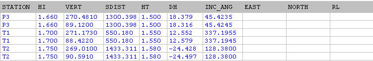
See the example of a typical input file (Easting, Northing and RL values will be inserted by the function):
Reduction method
Choose the reduction method.
- DH/HZ DIST is used when the raw data consists of reduced height differences and horizontal distances.
- VA/SLOPE DIST is used when the raw data consists of measured vertical angles and slope distances.
- STADIA uses the same prompts as the VA/SLOPE DIST option. In this case however, the height difference and horizontal difference are calculated differently, using the algorithm used by the Survey | Field Reductions | Stadia function.
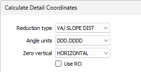
Angle units
Choose the units that will be used to display the angles:
- DDD.MMSS for degrees minutes seconds.
- DD.DDDD for decimal degrees.
- DDDMM.MMMM for degrees and decimal minutes.
Zero vertical
Choose the zero vertical parameter:
- ZENITH means that 90 or 270 is horizontal; <90 or >270 is an elevation and >90 or <270 is a depression. HORIZONTAL means that 0 is horizontal, positive values are elevations and negative values are depressions.
Use RO
If you are using a reference object, select the RO check box. This is not required if the horizontal angles are true bearings.
Station file
Double-click to navigate to the location of a Station file. This file contains the names and coordinates of known survey points and is used when the coordinates are being calculated.
Station fields
Click on this button to enter the required field names. Some fields will be disabled depending on the reduction type chosen.
When adding new station
When adding a new station to the output file, if the station name already exists in the file , new radio button options allow the user to choose whether to keep the original (East, North, RL) values, overwrite the original values, average the values, or be prompted to choose an action.
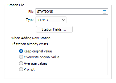
Prompt will bring up a dialog each time an existing Station name is encountered, displaying the Station name, the original (East, North, RL) values, new values, and the difference between the original and new values. Radio buttons are presented, allowing you to choose a (Keep, Overwrite, Average) action.
You cannot edit the values presented in the Prompt dialog.
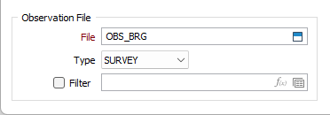
Observation Fields
Enter the survey observation file name and specify fields:
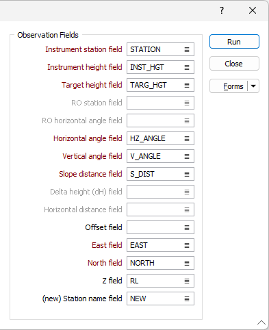
- Enter the name of the field that will contain the Instrument station names.
- Enter the name of the field that will contain the Instrument height values.
- Enter the name of the field in the file that will contain the Target height or (for the STADIA reduction method) the Middle wire reading.
- (If the Use RO option is selected) Enter the name of the field that will contain Reference Object RO station identification. The coordinates of the ROs defined in this field will be read from the Station file.
- (If the Use RO option is selected) Enter the name of the field that will contain the RO angles. When RO Horizontal angle is not defined it is assumed to be 0.000.
- Enter the names of the fields that will contain Vertical angle and Horizontal angle values.
- Enter the name of the field that will contain the Slope distance or (for the STADIA reduction method) the STADIA distance.
- (For the DH/HZ DIST reduction method) Enter the name of the field that will contain Delta height differences between observations.
- (For the DH/HZ DIST reduction method) Enter the name of the field that will contain Horizontal distance values.
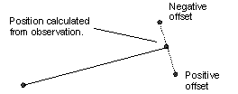
- If you specify an Offset field, its values will be used to move the coordinates by the amount indicated in each point. (A positive value shifts the point to the right.)
- Enter the name of the fields that will contain Easting, Northing and RL coordinates.
- Enter a New station name value if there is a new station identified in a field that is blank for all records except when an observation is made to a new fixed point. The station and its coordinates will be written to the observation file. The most common use for this is in an open traverse, when the last observation is to the next setup station. You don’t need to enter the information manually into the observation file.
Run
Run the function to write the calculated fields to the survey observation file.