Polygonal Restriction
The polygons in a String Filecan be used to restrict the data that is used as input to the gridding process:
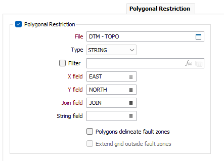
File
Double-click (F3) to select the String file that contains the polygons you want to use to restrict the data. Optionally, apply a Filter to limit the records to a particular subset of data.
X, Y fields
Double-click (F3) to specify the names of the fields in which Easting and Northing coordinates are stored.
Join field
In forms that require polylines as an input, the values in this field define whether the data points in the input file should be joined by a line. If successive records have the same value in this field, a line will join the points. If two-factor topology is required, the values in a String field may also be used to segment the lines.
String field
In most forms, the String field is an optional generic attribute used to store a secondary input such as a code. Traditionally, this field has also been used with the Join field to define whether data points should be joined by a line, or strung, hence the name.
Polygons delineate fault zones
This option is only enabled when the Polygonal restrictions checkbox option is selected. When the Polygons delineate fault zones option is selected, only the points inside the same polygon as the elevation grid node, will be used to interpolate the elevation grid node value.
Extend grid outside fault zones
This option is only enabled when the Polygons delineate fault zones check box option is selected. When this option is selected, elevation grid cell values will also be generated for points that fall outside the restriction polygons.
The selection of points used for the interpolation of each grid node is still influenced by the Polygons delineate fault zones option. Selection of this option ensures that if a grid node is located outside of all polygons, it will still receive a value; however the points used for the interpolation of that value must also be located outside of all polygons.
Run
Click Run to begin the elevation grid creation process.