Survey
This
Downsize Voxel Method
Support for the Downsize Nearest Neighbour voxel method has been added to the Point Cloud Filter (Downsample) tool.
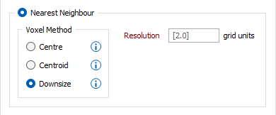
The Downsize Nearest Neighbour voxel method uses the first point found inside a voxel as the output point. The process will calculate the first point inside each populated voxel and mark the voxel as populated. All other points in the voxel are discarded (filtered out). This method uses less memory and is recommended for large inputs.
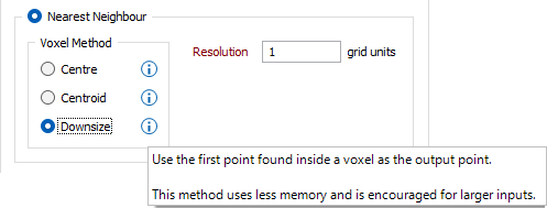
Prompts added to each Voxel Method will display an explanation of the method on hover:
The Voxel Downsize option has also been added to the Import Point Cloud tool.
Point Count Display
The point count for an input file is now displayed on the Point Cloud Import form:
The Points in file count from the selected file is displayed under the File field. This information and more is also available if you hover on the Input file field.
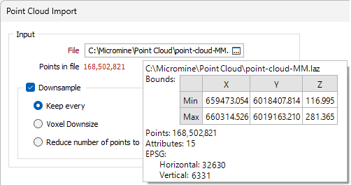
The Points in file count display will change according to the number of points in the total. Additionally, a context-sensitive tooltip will be available for the following ranges of total point count:
-
0 - 20M - The point count will be Green and the tooltip will read "For a small number of input points downsampling is not required.".
-
20M - 100M - The point count will be Orange and the tooltip will read "For a larger number of input points downsampling is recommended. For weaker hardware prefer memory optimised downsampling methods (as indicated).".
-
100M+ - The point count will be Red and the tooltip will read "This number of points may not be able to be displayed in Vizex. To prevent this from happening downsample using the options below. Prefer memory optimised downsampling methods (as indicated).".
Point Cloud Coordinate Conversion
The Coordinate Transform options have been added to the Import Point Cloud form on the Survey tab, in the Import group to allow coordinate conversion on import.
![]()
The Target EPSG conversion option will convert the Source coordinate system to the coordinate system defined by the Target EPSG code. The correct coordinate system can be searched for by pressing the search icon (magnifying glass). The Target EPSG option will only be active where the input file metadata contains a compatible CRS system.
The Conversion option enables you to apply a coordinate system conversion to the coordinates from a Coordinate System Conversion form set. Alternatively, you can right-click to create a new formset.
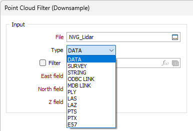
Point Cloud Filter File Types
Support for the PLY, LAS, LAZ, PTS, PTX and E57 file types has been added to the Ground, Noise and Downsample Point Cloud Filters:
Some Input fields, such as Easting, Northing and Z and some Output options such as Flag Records and Exception File are not required for the newly supported file types.
For information on Point Cloud Filters, see Point Cloud.