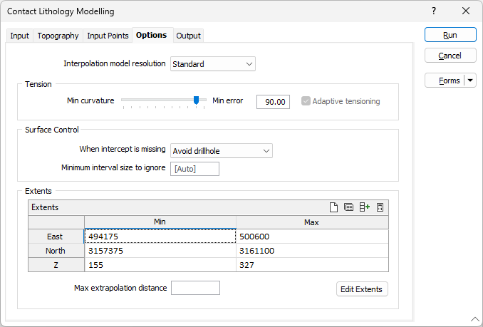
Options
On the Options tab of the Contact Lithology Modelling form, set the parameters and define the surface area (extents) for the interpolation.
Interpolation Model resolution
Select a Dynamic, Standard, Fine or Superfine resolution for the output model. The option you select will determine the size of the blocks (grid spacing) for the area of interpolation.
Dynamic is the default option and will automatically adjust the resolution depending on the density of the data model, providing better than Superfine resolution in much less time.
Note that the Dynamic, Fine and Superfine interpolation resolution options may require a modelling parameter file to be stored in your Windows Temp directory and may take up to 1.5GB of space.
Tension
Use the slider to set a tension value between 0 and 100, where smaller values favour smoothness (minimum curvature) and larger values favour accurately honouring the contacts (minimum error). The default is 95.
When Dynamic is the selected resolution option, an Adaptive Tensioning check box option is enabled. Select this option when trying to model problematic data, for example, a surface which undulates very rapidly.
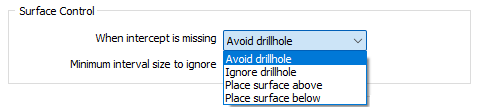
Surface Control
Choose where the surface should be placed when lithology codes are missing in adjacent holes.
Choose which action to take when an intercept is missing:
| Action | Description |
|---|---|
| Avoid drillhole | Avoid drillholes without contacts by automatically placing the surface either above or below the holes in such a way as to minimise the curvature of the surface. |
| Ignore drillhole |
Allow the contact surface to pass through drillholes without intercepts. . |
| Place surface above | Ensures the contact surface will pass over drillholes with no intercepts. |
| Place surface below | Ensures the surface passes under drillholes with no intercepts. |
Extents
Define the area of interpolation:
East, North and Z fields
Specify the Minimum and Maximum extents of the surface in the East, North and Z directions.
Max extrapolation distance
Enter a maximum extrapolation distance buffer that makes sense relative to the spacing of your data. This will delete any wireframes outside this area. Typically, it is better to either have no extrapolation distance buffer, or have a large extrapolation distance buffer - this can then be decreased if you notice any relics or unwanted wireframes a long distance away from your data.
Edit Extents
Click the Edit Extents button to collapse the form and visually adjust the extents, automatically aligning the extents to a restriction rectangle in Vizex. Interactively adjusting the extents rectangle in the Vizex display, or in the Vizex Property Window, will update the values in the form.
See: Edit Extents