Contour
![]()
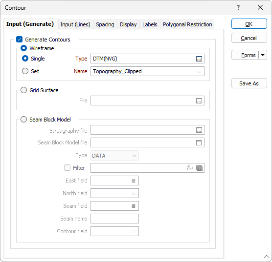
The Contour form provides a choice of two input modes, split over two tabs. These two modes allow you to choose whether the contours are generated by the function from specified inputs, or whether they are defined as lines in a String file.
You can control the contour line spacing, using regular or irregular intervals, control the type of line, line colouring, labels, and how smoothing is applied.
Input (Generate)
Select an Input type and double-click (F3) to select the name of the Wireframe, Wireframe Set, Grid file, or Seam Block Model file containing your data.
Wireframe
To process a single wireframe, select the Single option, select the Type of the wireframe, and then the Name of a wireframe of that type.
To process multiple wireframes, expressions, wildcards and partial names may be used in the Name field to select multiple wireframes as an adhoc wireframe set. A right-click Preview option will perform a check of an expression before using that expression to generate an updated list of wireframes. Alternatively, you can click the Expression icon ![]() and use the Expression Editor to create, modify and validate the expression. When a name or wildcard is entered in the Name field, and the Expression button is selected, the name/wildcard will automatically be converted to a valid expression when opened in the editor.
and use the Expression Editor to create, modify and validate the expression. When a name or wildcard is entered in the Name field, and the Expression button is selected, the name/wildcard will automatically be converted to a valid expression when opened in the editor.
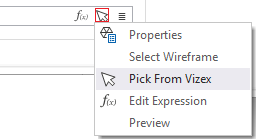
You can also select the Wireframe Name using the Pick From Vizex button (or context menu option). The option will collapse the form and allow you to interactively select a wireframe in Vizex to enter it into the relevant fields.
To process the wireframes in a predefined wireframe set, select the Set option.
It is recommended that you Validate wireframes prior to using them in any process.
Grid Surface
Double-click (F3) to select the name of the input Grid Surface file.
Seam Block Model
Stratigraphy file
The selection of a Stratigraphy file allows the Seam name to be selected. Together with the Seam field in a Seam Block Model file, this effectively defines a filter, Seam Field = Seam Name, which allows an attribute associated with a seam (Ash, Volatility, Thickness, RD, etc) to be contoured.
Double-click (F3) to select the name of the input Stratigraphy file. A Stratigraphy file is a compiled file that is used to interpolate and display the stratification of the seams in a Seam file.
You can right-click (F4) in the File box to view the Stratigraphy file and manipulate the stratigraphy sequence.
Seam Block Model file
Specify a Seam Block Model file as the input file. Seam block models use variable-height blocks, which are not limited to a set sub-blocking interval. Seam splits, plies and partings are easily defined.
The conventional filter is available if only a subset of that layer needs to be contoured (for example, a specific fault block, or to exclude negative values).
East and North fields
Double-click (F3) to select the name of the East, North and Z coordinate fields in the input Seam Block Model file.
Seam field
Double-click (F3) to select the name of the field that contains the values used to identify each seam.
Contour field
Double-click (F3) to select the name of the field containing the data to be contoured.
Forms
Click the Forms button to select and open a saved form set, or if a form set has been loaded, save the current form set.
By design, the Forms button is not available for loaded Vizex layers (i.e. when opening the form set properties of a layer in the Vizex Layer Display pane). In Vizex, the Forms button is only available for new forms opened via the Home tab or the Vizex tab, in the Layer group (or by double-clicking on a form type node in the Vizex Layer Types pane).
Save and Save As
Click the Save button to save the changes you have made to the form set. Click Save As to save your changes as a new form set. Save As will default to the first available form set number.
Reset
Click Reset to clear the form of all values and reset the form to its default state.
Reset Tab
For tabbed forms, select Reset Tab to clear the active tab of all values and reset the tab to its default state - without making any changes to other tabs in the dialog.
Undo and Redo
Click Undo (CTRL + Z) to undo recent changes in the form. After an Undo, click Redo (CTRL + Y) to restore the last change that was undone.
Collapse
Collapse (roll-up) the form to preview a chart, or preview the results of an operation in Vizex, or obtain input values from Vizex, the Property Window, the File Editor, or the Plot Editor.