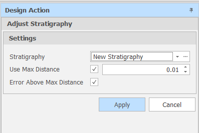
Adjust Stratigraphy
This utility will process the grids in a stratigraphy from top to bottom and find any points in the next grid that are above the points in the current (above) grid in the same area and, in such cases, adjust the points to be inline with the current (above) grid.
![]()
Settings
Stratigraphy
Use the drop-down to select a Stratigraphy. Alternatively, click on the ellipsis to open the Setup Stratigraphies Setup Window,
Use Max Distance
Select the Use Max Distance check box to impose a maximum distance between the grids in the stratigraphy. Use the spin controls to set a Max Distance value.
Error Above Max Distance
When the Use Max Distance check box is selected, select the Error Above Max Distance check box to raise an error when the maximum distance between the grids in the startigraphy is exceeded.
You can also click an Adjust Grid Height button at the bottom right of the Setup Stratigraphies dialog to run the Adjust Stratigraphy utility. In this case, a Maximum Distance check is not applied.
Apply
Finally, click Apply to apply the specified layering requirements.