Files & Projects
This
Export GIS Feature Types
The option to output Points, Lines and/or Polygons and provide a custom Suffix has been added to GIS Export:
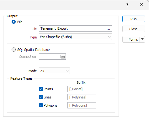
Selecting any or all of the options determines what features are exported from the Input file. If one option is selected, such as Points, the entire Input file will be treated as points; if other feature types are enabled, each feature in the file will be treated as the applicable type.
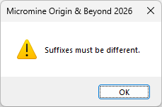
Note: Suffixes must be unique and an alert will be displayed if they are not:
Export to Google KMZ
Support for exporting compressed Google KML files (.kmz) directly from Micromine Origin & Beyond has been added to the Google KML export tool on the File tab, in the Export group.
Keyhole Markup Language (KML) is an XML-based language for managing the display of 3D geospatial data. For its reference system, KML uses 3D geographic coordinates: longitude, latitude and altitude. The longitude and latitude components are as defined by the World Geodetic System of 1984 (WGS 84).
A KMZ file is a compressed version of KML containing all of the linked resources (e.g. icons, images, overlays) bundled into one file. You can open a KMZ file in Google Earth® to view the details of the export.
The KMZ format is often required for government submissions and environmental approvals.
For more information, see Google KML.
Improved ODBC Support
Support for additional SQL Types has been added to the ODBC functionality for Import and Export.
The following SQL Types have been added:
-
float
-
text
-
nText
-
dateTimeOffset
-
time
Additionally, timestamp and date values will now correctly be treated as characters and deselected fields will not be considered for table structure.
For more information, see ODBC.
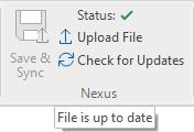
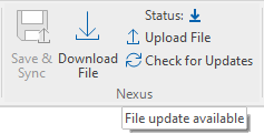
Nexus Group Tools
The following tools have been added to the File | File Editor ribbon in the new Nexus group to provide synchronisation of the file open in the editor with Nexus.
-
Select Upload File to upload the open file to Nexus.
-
Select Download File to download the latest version of the open file from Nexus. Download File is available when a change has been made to the open file in Nexus.
-
Select Save & Sync to save and upload the open file to Nexus without opening the Nexus window. Save & Sync is available when changes have been made to the open file.
-
Select Revert File to revert the changes to the file currently opened in the editor.
-
Select Check for Updates to check with Nexus for updates to the file currently open in the File Editor. If a newer version of the open file is available, the Download File option will be enabled.
Additionally, the current Status of the open file is displayed in the Nexus group
|
|
Georeference Label Display
The displayed georeference label symbol for the Georeference Image tool on the File tab, in the Image group has been improved to make them more visible for all images including black and white.
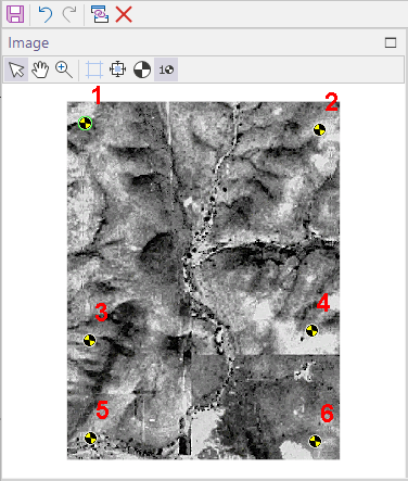
The black and yellow symbol (in the style of safety signage and 'crash test dummies') is brighter and more contrasting with dark and monochrome images.
For information on using the tool, see Image Georeference.