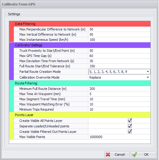
Calibrate from GPS Options
The Calibration Setup comprises several variable groups, whose values can be adjusted to help fit data to the network.
Data Filtering
Max Perpendicular Difference to Network (meters)
-
Max distance a point can be from a segment to be considered valid and part of the network for X and Y axis. (Z axis handled below)
-
A value of 50 meters means a point will be considered valid within a 50 meter distance around all parts of a segment
-
Invalid points may still be considered by the calibrator, but this requires the data to come back within the distance tolerance before Max Deviation Time From Network limit is hit.
-
Recommended minimum: 50 meters
Max Vertical Difference to Network (meters)
-
Same rules and effect as Max Perpendicular Difference to Network (meters) but for the Z axis only.
-
Can be used to better fit routes to ramps.
-
Recommended minimum: 20 meters
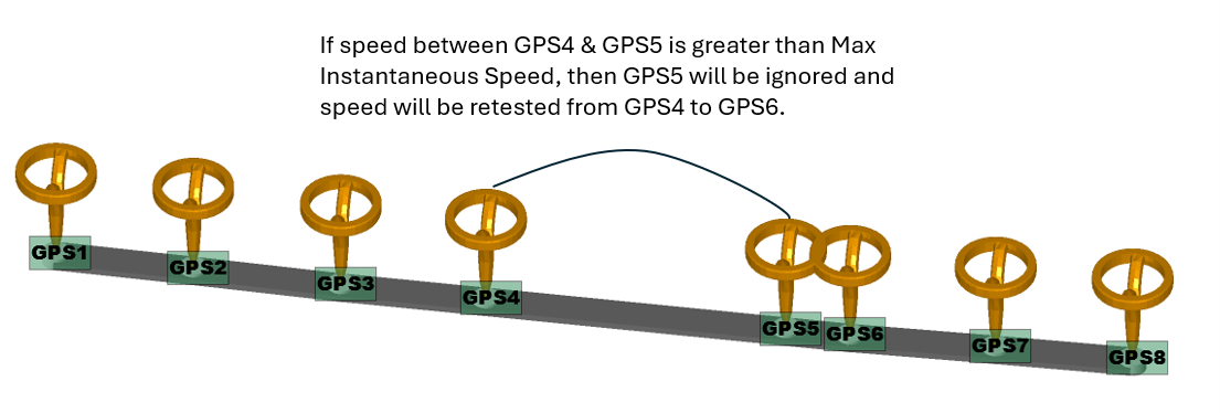
Max Instantaneous Speed (Kmph)
-
Max speed between two sequential GPS points. This is calculated based on the distance and time between the two points.
-
Skips points over this value to smooth out jumps/errors in the GPS data.
-
Recommended maximum: Double the predicted speed.
Calibrate from GPS Options (Top)
Calibrator Settings
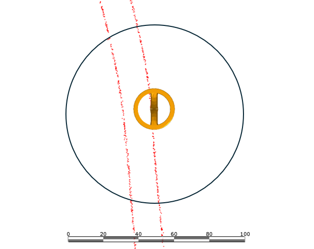
Truck Proximity to Start/End Point (m)
-
Minimum distance that is required for a point to be considered at a waypoint. Used for creation and termination of routes, and for when passing waypoints along the route.
-
If multiple points are within the proximately, only the closest will be considered at the waypoint.
-
Recommended minimum: 50 meters
Max GPS Time Gap (seconds)
-
Maximum time gap between two sequential GPS points. Could occur when signal is lost or machine was switched off.
-
It is recommended that GPS data falls between 2 - 5 seconds per GPS point. If that time between GPS points is greater than the Max Gap, the route will be split into two: one before and one after the gap.
-
Recommended minimum: 15 - 30 sec
Max Deviation Time From Network (seconds)
-
Max time a truck can be outside of Max Perpendicular Difference to Network and Max Z difference from network before the route will be split into two: one before and one after the gap.
-
Good for wide corners or some irregular roads that don't quite fit the network.
-
Recommended: 10 - 30 sec
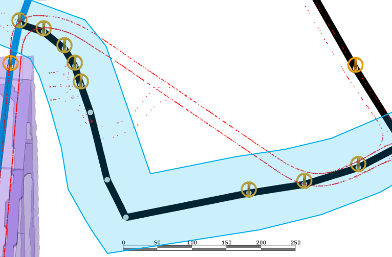
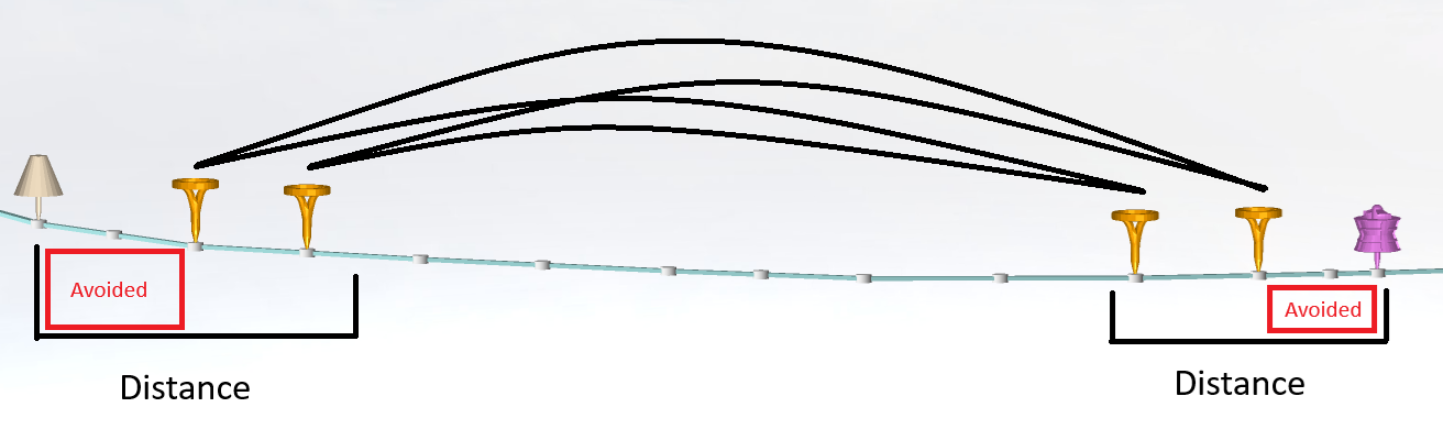
Full Route Start/End Tolerance (meters)
-
Distance used to create extra routes to catch mismatches occurring at the start and end of routes. Avoids noisy areas near the start and ends of routes.
-
A value of 0 meters would only use start and end waypoints of a full route for calibration.
-
Example below is of 350 meter distance. Waypoints are added in the second half of the distance and then each starting waypoint will create a route to each end waypoint, resulting in 2x2=4 calibrations for the route in this example.
-
Maximum waypoints created is 3 on each end for 3x3=9 calibrations.
-
Recommended: 200-400 meters. Enough distance for a truck to leave the noisy data area of its source and destination.
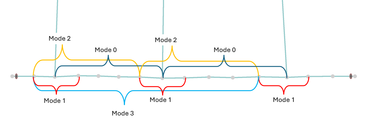
Partial Route Creation Mode
-
Determines how often calibrations are created for intersections along a route.
-
Useful for filling in data gaps where full routes might not be available.
-
Involves start/ends of intersections to get the correct data for cornering.
-
A mode of 0 will create calibrations between the middle of an intersection along a route to the middle of the next intersection.
-
A mode of 1 will create calibrations from the start of an intersection to the end of the same intersection.
-
A mode of 2 will create calibrations from the start of an intersection to the start of the next intersection.
-
A mode of 3 will create calibrations from the start of an intersection to the start of the next, next intersection etc. Example below.
-
Recommended to have all partial route options selected.
Calibration Overwrite Mode
-
Determines the effect of this calibration on existing calibrations.
-
Replace: Deletes all previous calibrations and replaces them with this calibration.
-
Merge: Appends new calibrations and merges existing calibrations with matching new calibrations. Uses a weighting system based on how many routes from the data were used to create the calibration.
NOTE: Calibrations that were imported using a .cali file will exist separately and will still be used unless there is a GPS calibration for the current segment available.
Calibrate from GPS Options (Top)
Route Filtering
Minimum Full Route Distance (m)
-
Specifies the minimum distance for a calibration to be considered valid. This is total distance from the start waypoint to the end waypoint.
-
Higher values will reduce the creation of “noise” trips that could be created in very high density areas that only span 2 or 3 segments.
-
Recommended Distance: 200 meters or higher based on the smallest route a truck would take that would produce a useful calibration.
Max Time At Waypoint (min)
-
Specifies the maximum time in minutes that a truck can sit at a waypoint until the current route is discarded.
-
Lower values can reduce calibrations that include unusual truck activity where it has stopped at a waypoint but GPS points are still being created.
-
Recommended Time: 5 minutes. If there is an intersection that has a long queue it could be discarded so this value should be higher than that expected time.
Max Segment Travel Time (minutes)
-
Specifies the maximum time in minutes that a truck can take to traverse a single segment until the current route is discarded. Similar to Max time at waypoint (minutes) but for when a truck is at the middle of a segment.
-
Recommended Time: Can vary, should also be longer than the longest queue time.
Max Waypoint Matching Error (percent)
-
Determines the maximum effect a point not perfectly matching with a start/end waypoint can have on a calibration route.
-
If the last GPS point of the calibration route is 35 meters away from the end waypoint and the calibration is only 100 meters. The possible error is 35%.
-
Longer calibration routes will have much smaller errors as the distance will only be a small proportion.
-
Error distance is measured in the direction of travel. This is to remove the perpendicular distance for wide roads.
-
Recommended value: 10%
Minimum Trips Required
-
The minimum amount of times a truck type must complete a particular trip for it to count as valid and to be imported. Does not need to be a full cycle, just A → B.
-
Reduces routes with low traffic where the average time may not be representative.
-
Recommended value: 10
Calibrate from GPS Options (Top)
Points Layer
Create Visible Points Layer
-
Enables/disables automatically creating a layer in the layers panel with GPS points used for visual inspection.
Separate Loaded/Unloaded Points
-
Enables/disables separating points into two layers that show the truck load state.
-
Only available when above option is enabled.
Create Visible Filtered Out Points Layer
-
Creates a layer what GPS points have been filtered out by the filtering settings above.
NOTE: These points are still used by the calibrator but follow specific rules.
Max visible points
-
Limits the visible points for large datasets. Points will be spread out evenly so a lower value will just reduce density.