Map GPS .csv
Calibrating the haul network using the Map GPS .csv data, removes the need to manually create waypoints and calculate haul times outside of HI.
To use this method, data must be arranged in columns and provide enough information to obtain the following information.
For example: Payload can be used with a Custom Variable to determine if the truck is loaded or empty.
| Required Field | Purpose |
|---|---|
|
Truck Name |
Used to identify unique haul cycles. |
|
Truck Type |
Used to determine which fleet the movement belongs to. These need to match the Truck types setup in HI. |
|
Loaded (y/n) |
Used to determine if the haul cycle falls under loaded travel or unloaded travel. |
|
Timestamp |
Used to determine if the truck is moving and how fast or if it is stationary based on GPS location. |
|
GPS Coordinates (x,y,z) |
Used in conjunction with timestamps to determine speed. |
Importing Data
-
Select the Calibration – Map GPS .csv option from the Extensions menu.
-
Select the .csv file to import.
-
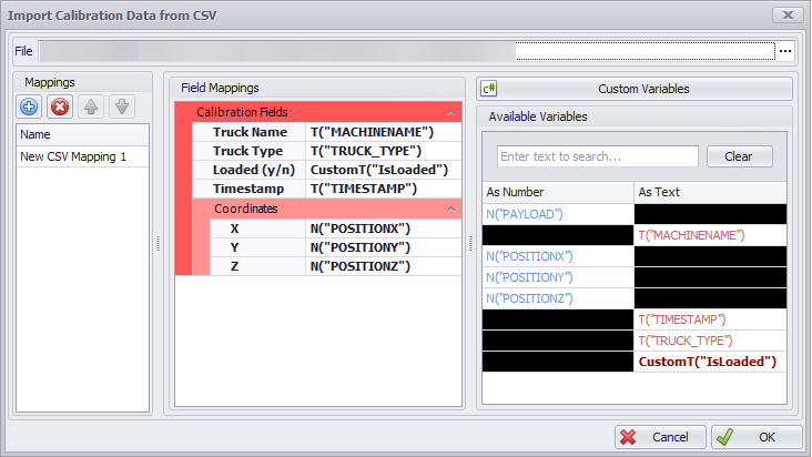
Click the Blue Plus Icon to add a new mapping. Mappings will be saved for use with future imports.
Available Variables will be shown on the right-hand side once a file has been selected.
-
Map the required fields from the Available Variables to the Field Mappings. This can be done by dragging and dropping, or by selecting a field and double-clicking on the appropriate variable.
Custom Variables can be used to process the data into the required output. For example:
public class IsLoaded : ITextCustomVariable
{
public string GetText(CustomVariablesContext context)
{
return context.N("PAYLOAD") > 100 ? "y" : "n";
}
}
-
Once everything is mapped, click OK to read in the data.
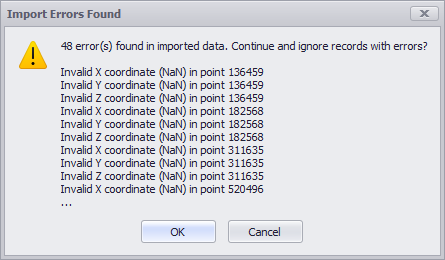
In some cases, ‘bad’ data may be present in the data. These will be identified and ignored as part of the Import process.
Calibration setup has several variables which can be adjusted to help fit data to the network. For more information, see: Calibrate from GPS Options