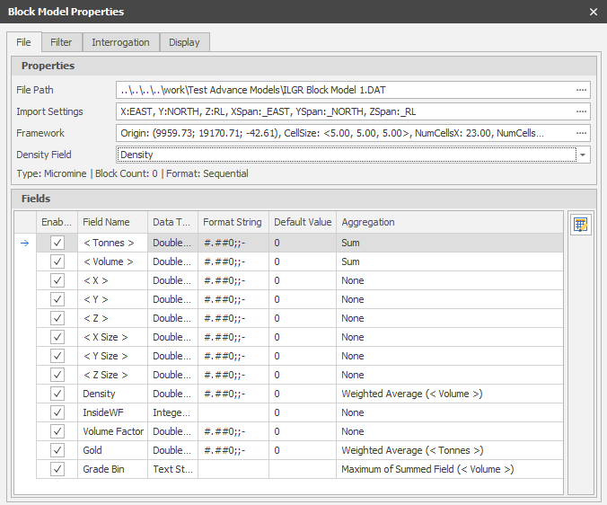
File
Typically, block models can be used as a background layer to define the area of interest, for example, during pit design. When you are in Plan view, and have the 2D Slice draw style selected, the blocks you see are restricted to those which intersect the current Z value.
Be aware that if you use a Block Size Factor, the current Z value may fall "between" the blocks in your model, and you may not see anything in the display. Either change the Block Size Factor or change the Z value in the display limits.
Properties
File Path
The file path of the Block Model File at the time it was imported. Click on the ellipsis to navigate to the location of another file.
A summary of the Type of the file you have selected, a Count of the number of blocks in the file and its Format, are shown below the Framework input box.
Framework
A Block Model Framework defines its origin, extents (as defined by a specified cell size and the number of cells in each XYZ direction) and (optional) its rotation on three orthogonal planes that intersect at the camera viewpoint.
To view or edit the framework, click the ellipsis to the right of the Framework input box.
Fields
A preview of the Fields in the Block Model File is shown here. Field names and Data Types cannot be altered. The following settings can be applied to each field:
Enabled
Choose whether to include each field in the layer properties.
Format String
The Format String controls the way the data appears, but doesn't affect the data itself. The Format String nomenclature is based on C# standards. For a summary, see: Format Strings
Default Value
Optionally, specify a default value for the field.
Defining Block Model Fields and Aggregation
(Default: Sum) How the data will be aggregated when filtered (typically Sum when dealing with quantities).
If you have selected a Position that is not in the lowest Level you will see an aggregated (summary) view. Certain Field types (Solid, Point3D and Bool) cannot be aggregated and will always appear blank. Others will appear blank if an Aggregation has not been set (or is set to None) in the Fields setup.
In the screenshot below, notice that some block fields have aggregation set:
In the context of Block Model Interrogation, if a triangulation only has a single block intersecting it, then aggregation is irrelevant and the fractional block value will be written to the respective attribute of the triangulation. If a triangulation has multiple intersecting blocks, then the aggregation of those intersecting blocks is written to the respective attribute.
This is important because if a field has an aggregation of ‘None’, then nothing will be written to the respective attribute because no aggregation has been/can be defined.
Always ensure that block fields have reasonable aggregations.
Secondly, notice the Density field in the Properties group. This field is important because it informs the value of the < Tonnes > field in the Fields group. Tonnes is an intrinsic field which is calculated with the following formula (Tonnes = Volume * Density). Without a Density field set, the tonnes will always be the default value.
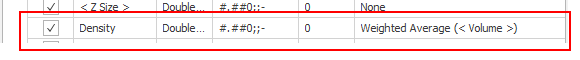
Always ensure that the Density field is set if relying on values from the < Tonnes > field.
|
|
Use the Bulk Editor to make bulk modifications to the items in the list. |
Apply
Click Apply to update the Block Model Layer with any changes you have made. The Block Model Properties window remains open.
Accept
Click Accept to Apply the changes you have made (see above) and close the Block Model Properties window.
Close/Cancel
When no change has been made, click to Close the Block Model Properties window.
When changes have been made, click Cancel to discard your changes and close the Block Model Properties window.