Collar File
The Collar File tab of the Import Drillholes form is used to configure the Collar file for the import.
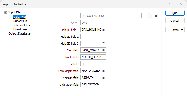
Information in the Collar file selected on the Input Files tab (such as the Hole ID field and East, North and Z fields) will be autofilled to the fields on the Collar File tab where available. Some fields cannot be autofilled.
You can use the Clear button to clear the contents of the fields on the tab. The Calculate button will attempt to autofill the fields based on the information in the corresponding file.
Hole ID fields
Where required, double-click to select the name of the field that contains an identifier for each hole.
Easting, Northing and Z fields
Double-click to select the names of the fields that define the coordinates of the collars in the Collar file.
Total depth field
Double-click to select the name of the field that contains the total depth of each hole.
Azimuth and Inclination
Azimuth and Inclination values may also be stored in the Collar file where the direction is defined by a single survey. Where the Collar file does not include azimuth and inclination information and a Survey file is not used, the holes are assumed to be vertical.
Use the Survey File tab of the form to configure the details of any Survey file for the import.
Run
To begin the import process, click the Run button. If the specified output file already exists, you will be given the option of overwriting the file, or appending data to the file.