Geology Toolkit
The Geology Toolkit enables users to record a visual estimate of material features on location, in the field and offline. Pitram Connect undertakes calculations while offline, and these can be passed to the Pitram Server for processing when the user is online. Location records are then updated with the data applied to material movement records based on the date/time of the entry.
Requirements
For the Geology Toolkit to be active for a user, a number of prerequisites must be met:
Reference Data
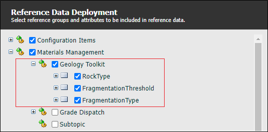
The following Reference Data must be deployed for the Geology Toolkit:
-
RockType - Observation rock types. These tokens define the rows of the Material Observations list in the Geology Toolkit. E.g. $M, HG, LG, BUM, FELSIC.
-
Domain attribute is used to map rock types in the Elemental Grades Importer CSV files.
-
Order attribute is the display order of the tokens in the UI, can be blank for alphabetical order.
-
-
FragmentationThreshold - Thresholds for observed fragmentation types. These tokens define the rows of the Fragmentation Observations table displayed in the Geology Toolkit. E.g. < 0.4, < 1.0, < 2.0, > 2.0.
-
The Order attribute is the display order of the tokens in the UI, can be blank for alphabetical order.
-
-
FragmentationType - Observation fragmentation types. These tokens define the columns of the Fragmentation Observations table displayed in the Geology Toolkit. E.g. FRAG Ultramatic, FRAG Felsic.
-
The Order attribute is the display order of the tokens in the UI, can be blank for alphabetical order.
-
-
Element - DisplayInGeologyToolkit element - Only elements with the attribute will show up in Pitram Connect and be used for calculations in the stockpile survey screen.
The ContentUomDecimalPlaces attribute can also be optionally set for the grades formatting.
-
Tonnes Formatting - This is taken from the DecimalPlaces attribute for Measure Tonnes.
-
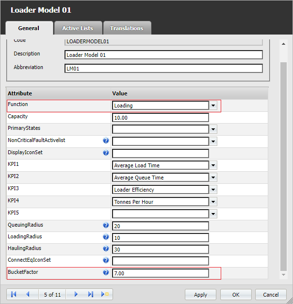
Equipment and EquipmentModel - BucketFactor element - Only equipment that has the BucketFactor attribute set are able to be used in an observation. This will commonly be set on the Equipment Model.
Also note that Loaders (equipment set with a LOADING function ) will be available in Pitram Connect.
Server Versions
The supported Pitram and Pitram Portal versions are 8.0 and above. The supported PRIS version is 1.11.0.37 and above.
Stockpile Survey Screen
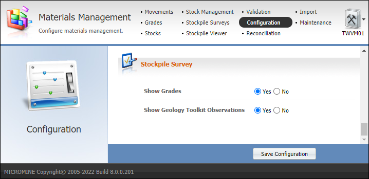
By default, the display of Geology Toolkit observations is disabled in the Stockpile Survey screen, To enable them, navigate to Materials Management | Configuration and set Show Geology Toolkit Observations to Yes and save.
If using the sample values outline in Reference Data, the Stockpile Survey screen will now show headers similar to the following:

Elemental Grades Importer
The elemental grades importer can be accessed on the Stockpile Survey screen using the Import Elemental Grades button:
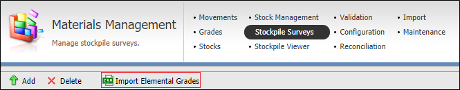
It is used to import CSV files containing elemental grades for a particular location. These grades are then used in Geology Toolkit observation grade calculations.
Below is an example CSV file containing 10 elemental grades (5 domains (rock type) * 2 elements). The areas highlighted in red relate directly to reference data.
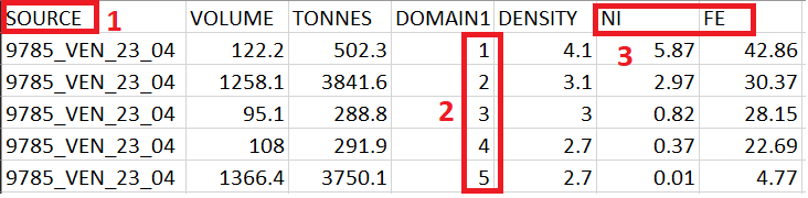
These values must be present before the CSV file can be imported:
-
The location of the elemental grade
-
The domain column maps directly to Reference Data rock types. Domain cannot be repeated for Location/Element/Domain combinations.
-
The imported elements do not need to have the attribute ShowInGeologyToolkit enabled to be imported, but this is required for them to be considered in calculations or Pitram Connect.
For more information, see Elemental Grades Importer.
User Roles
For the Geology Toolkit to be available to a user, they will need the Geology Toolkit application enabled with one of their associated roles:
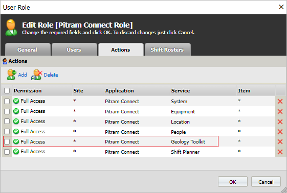
Once the application is added to the role, the user may need to logout and login to Connect to refresh the security token containing the new authorisation.
Operation
The Stockpile Survey screen allows the editing and deletion of grades, stockpile surveys and geology toolkit observations. Grades and stockpile surveys can also be created, but observations can only come from Pitram Connect.
Information on using the Stockpile Survey screen is contained in Stockpile Surveys.
For information on adding an observation, see Using the Geology Toolkit.