Survey file
The Survey file is made up of records containing a collar survey and other downhole surveys for each drillhole. A separate record is required for each survey and the following fields are required:
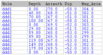
Hole ID
A Hole ID field containing an identifier for each drillhole.
Survey Depth
The depth at which the survey was made.
Azimuth and Inclination
The Azimuth and Inclination at the surveyed depth.
The collar survey for any drillhole can be recorded in either the Collar file or the Survey file. If it is in both, the values in the Survey file are used.
All surveys for a drillhole must be in consecutive records, sorted in order of increasing depth.
All survey depths must be less than or equal to the total depth of the hole and greater than or equal to zero. The total depth of each hole is defined in the associated Collar file.
A hole that does not have azimuth or inclination values in either the Collar or Survey files is assumed to be vertical.
When constructing a file that contains mixed reverse circulation (RC) and diamond drilling information, where some holes have single surveys and others have multiple surveys (recommended), place the collar orientation in the Collar file and subsequent surveys in the Survey file.
Occasionally, you will have two groups of azimuth data each referring to different Norths, for example Grid North and Magnetic North. You can adjust the azimuths in one group to match those in the other, by entering an azimuth correction value. This can be done in the Validate, Downhole Coordinates, and Downhole Trace functions.