Horizontal
![]()
Adjust Resection By
The steps to process the 3 point calculation as described in the Resection Coordinate Calculation topic. If more than three known points are observed than an adjustment is required.
The "Average" method is described in the Overview topic. For more information, refer to the Least Squares topic.
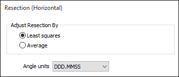
If there are only 3 Known points then it does not matter which option is chosen here.
Angle units
Select the Angle Units that will be used for latitude and longitude values.
Station file
The file containing the coordinates of the fixed points. Since this function does not calculate elevations, there are only prompts for the East and North field. The stations observed from the occupied (resected) location are expected to be found in this file.
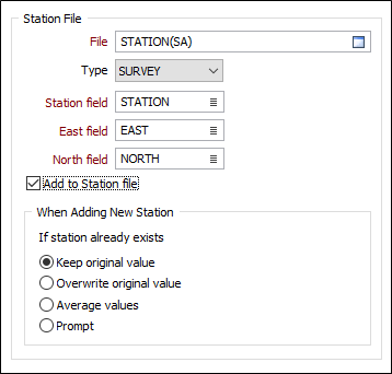
Add New Station
When adding a new station to the output file, if the station name already exists in the file, new radio button options allow the user to choose whether to keep the original (East, North) values, overwrite the original values, average the values, or be prompted to choose an action.
Prompt will bring up a dialog each time an existing Station name is encountered, displaying the Station name, the original (East, North) values, new values, and the difference between the original and new values. Radio buttons are presented, allowing you to choose a (Keep, Overwrite, Average) action.
You cannot edit the values presented in the Prompt dialog.
Add to Station file
If the occupied station is to be added to the Station file then select this check box. (If the station already exists in the Station file, the options behave in the same way as for the Detail Coordinate Calculation function).
Observation file
This is the file containing the observed angles from the unknown point to the known points. The "angles" can either be the observed direction to station, or the calculated angle to the previous station.
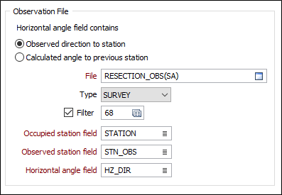
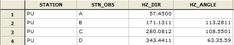
If the latter option is chosen then the horizontal angle field will be blank for the first record (see the example below).
To calculate the coordinates of the occupied station there must be observations to at least three known points.
Report fields
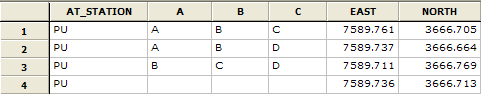
The field name prompts for the report file are dependent on the adjustment method. Using "Average" the report file will show the calculated coordinates for each "3 station" combination. The final record means those values.
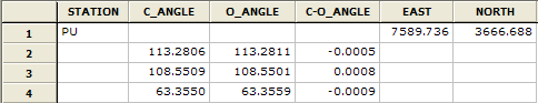
Using Least Squares, the adjusted coordinates are displayed in the first record. The subsequent records show each of the Calculated and Observed angles (and the difference). The C-O values give an indication as to the quality of the observations (an alternative is to display the calculated error in East and North.
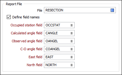
Report file
Enter or double-click (F3) to select the name of a Report file. If the Report file already exists, you will be prompted to Overwrite or Append.
There are three possibilities when specifying report output fields:
- (Average) Use the default fields
Occupied station - same name and field specification (type, width decimals) as in the Input file.
Station A, B and C - same field specification as the Observed station field in the Input file.
Names "A", "B" and "C". East and North as per the Station file.
- (Least Squares) Use the default field names
Occupied station - same field specification (type, width decimals) as in the Input file.
Angle fields - same field specification as Horizontal angle field in Input file. Names "CALC_ANGLE", "OBS_ANGLE" and "(C-O)ANGLE".
East and North as per Station file.
- (Average and Least Squares) Define the field names Enter the field names (compulsory) to be used in the Report file.