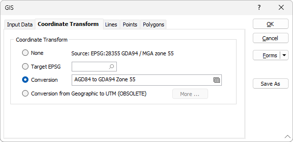
Coordinate Transform
Modern geospatial data are defined in numerous coordinate systems from around the world, which can complicate the process of combining them into a single view. A typical example involves converting government data (in latitude/longitude coordinates) to the working coordinate system of your project; another is converting historic data on an old geodetic datum to a modern geocentric datum.
None
If you do not want to convert between coordinate systems as you load your spatial data, select None.
There are currently two conversion options:
Target EPSG
This option is only enabled if the Input file contains recognisable information about the coordinate system that it was registered in. The EPSG number and name of the source coordinate system are provided if they are recognised.
If the Target EPSG option is selected, then the image is converted from the Source coordinate system to the coordinate system defined by the Target EPSG code. It is possible to search for the correct coordinate system by pressing the search icon (magnifying glass).

Conversion
Select the Conversion option to select or create a new coordinate conversion form set to convert between coordinate systems. See: Coordinate System Conversion
The application’s Coordinate System Conversion options support virtually any pair of coordinate systems. Most conversions are between recognised coordinate systems, and the application uses the EPSG (European Petroleum Survey Group) database to supply the parameters for well over 5000 coordinate systems and their conversions. The application also supports the high-precision distortion grid methods (also known as shift or difference grids) required by modern datums.
The process takes place in two stages:
- Define the conversion by choosing the origin and destination coordinate systems. This happens only once, and typically takes just a few seconds.
- Use it to convert your coordinates.
Once the conversion is defined, you can convert DATA (and related) files, wireframes, interactively via the relevant dialogs. This setup-once, use-many-times philosophy hides the conversion details and ensures that you always use the same parameters every time you run that conversion.
Conversion from Geographic to UTM (OBSOLETE)
To perform a geographic to UTM grid transformation, click on the More button to set the angle units and define the Spheroid that will be used for the transformation.
Functions tagged as obsolete are “end of life” (EOL) and will be removed from the application in a future version. For compatibility, these functions should still work in a macro, but it is recommended you replace them. Online help is not maintained for functionality that is marked as obsolete. If you have any concerns about a function being retired from service, please contact Micromine Australia Pty Ltd Support.