Polygonal Restriction
Polygons can be used to restrict the data that is used as input to various functions. To define which polygons will be used, select the String File or the Outline File input option in the Polygonal Restriction dialog.
String File
Select a file Type and then double-click (F3) to select the input File that contains the polygons you want to use to restrict the data. Optionally, apply a Filter to limit the records to a particular subset of data.
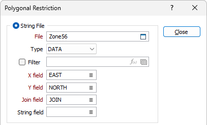
X, Y fields
Double-click (F3) to specify the names of the fields in which Easting and Northing coordinates are stored.
Join field
In forms that require polylines as an input, the values in this field define whether the data points in the input file should be joined by a line. If successive records have the same value in this field, a line will join the points.
String field
In most forms, the String field is an optional generic attribute used to store a secondary input such as a code. Traditionally, this field has also been used with the Join field to define whether data points should be joined by a line, or strung, hence the name.
Outline File
Double-click (F3) to select the input File that contains the outlines you want to use to restrict the data.
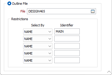
Restrictions
Choose either NAME or CODE from the Select By list.
Enter the selection criteria in the Identifier response or double-click and select an outline attribute from the list. Do this for up to 5 outline criteria. Use Wildcards to generalise identifiers. See Wildcards
By default all outlines in the specified Outline file are used.