Vizex
This
Coordinate Transform
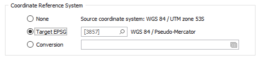
On the the Vizex tab, in the Layers group, when you select Display Layers | Image to load an image in Vizex, or select Display | GIS to load spatial data, a Target EPSG conversion option can now be selected.
This option is only enabled if the Input file contains recognisable information about the coordinate system that it was registered in. The EPSG number and name of the source coordinate system are provided if they are recognised.
If the Target EPSG option is selected, then the image is converted from the Source coordinate system to the coordinate system defined by the Target EPSG code. It is possible to search for the correct coordinate system by pressing the search icon (magnifying glass).
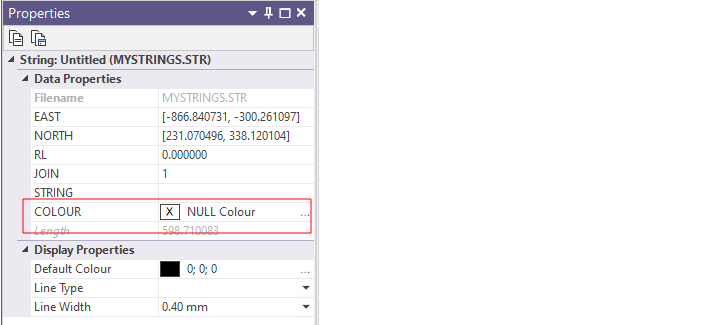
String & Point Colour Defaults
When strings or points in a new String or Point layer are created, a Colour field is now added to the Data Properties and is auto-populated with a default colour (initially NULL) that can be quickly changed in the Vizex Property Pane:
Display | String
A Use Custom Colour check box option has been added to the Show Line Markers group on the Points tab of the Display | String form. This option allows a custom colour to be applied to the line markers.
If this check box is NOT selected, the Colour box is disabled and the colour of the line markers will match the line colour that is set in the Colour Coding group on the Display tab of the form. This is useful when the line work is colour-coded and the marker colours need to match the line colour.

Text Box Annotations
The Text Box annotation now supports vertical scrolling of the text via the mouse wheel.

Colour blending has also been improved to reduce fringing around the edges of light-coloured text on a dark and mostly transparent fill-colour, and conversely, dark-coloured text on a light and mostly transparent fill-colour.
Performance Improvements
Operations such as zooming, panning, rotation, etc, are now improved for very large Drillhole layers. The speed of point selection in very large Point layers has also been improved.
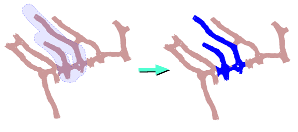
Paintbrush Selection Mode
A new Paintbrush Selection mode is now available on the Vizex tab, in the Pointer Mode group,
![]()
In this mode, you can use the paintbrush to draw a "ribbon" over the objects you want to select. Up and Down arrows can be used to increase or decrease the thickness of the brush stroke. Right-click to end the selection. You can also use the CTRL key with the mouse to make multiple selections.
On the Drillhole tab, in the Data group, you can also click Interval Selection to use the Paintbrush Selection mode to streamline the selection of drillhole intervals with a specific code.
![]()
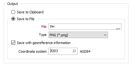
Generate Screenshot
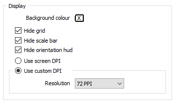
On the Vizex tab, in the Capture group, when you select Generate Screenshot to generate a screenshot (image) of the display, you can now select an option to write georeference information to the image file or an associated header file.
You can then double-click (F3) to search for a coordinate system by name or by EPSG (European Petroleum Survey Group) code:
New check box options also allow you to show or hide the reference grid, the scale bar and orientation arrows. These options are selected (hidden) by default:
Polyline Sections
On the Vizex tab, in the Section group, when you click Define Polyline Section to define multiple sections by digitising a (fence) polyline, the Polyline Section form is now opened automatically to allow section settings to be reviewed before the sections are created.
When panning and zooming in Vizex, the synchronisation between a polyline section and other views has also been improved.
![]()
Data Popup
The Data Popup window is now only shown when the Vizex window has keyboard focus. The current layer is also refreshed whenever a layer is set as the active layer. This ensures a layer is not accidentally deleted when trying to delete partially selected data in a layer that no longer has keyboard focus.