Coordinate Systems
This
Plane Grid Conversion
On the Survey tab, in the Coordinate Systems group, when you click Plane Grids to transform all the points in a file or a wireframe, improvements have been made to the way in which the points can be interactively picked:
-
Polygon Selection mode is now supported (interactively digitise a new closed string to select the points within it).
-
Lasso Selection mode has been improved so that Snapping is temporarily turned off when in use.
Auto load
Options to auto load the results in Vizex have also been added:
-
Auto load on the Convert File tab will auto load the transformed points or, if Join values are encountered in the file, auto load the transformed strings.
-
Auto load on the Convert Wireframe tab will auto load the transformed wireframe.
EPSG Coordinate System Default
On the Survey tab, in the Coordinate Systems group, when you click New to define a new coordinate conversion and click the Search icon to browse the EPSG coordinate reference system dialog, the currently used coordinate system (if any) is now selected by default.
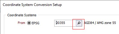
This makes it easier to query which coordinate system is being used in a particular form set.