Downhole Survey Data
Click the Build button to load or create the SQL query. The inclination and direction data that is obtained from the query is used to automatically calculate EASTING, NORTHING and HEIGHT coordinates expressed in the target coordinate system (specified on the Settings tab of the of the Plan View Property Editor).
The reference coordinate system is obtained from the query used to obtain the point data. Converted Easting and Northing downhole coordinates are then used to display the trace in Plan view by joining the points for each drillhole.
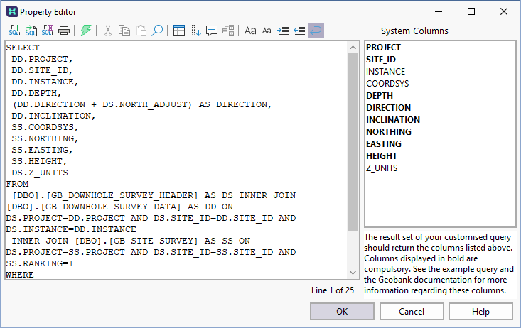
The list of system columns should be as follows (required fields are in bold):
PROJECT, SITE_ID, DEPTH, DIRECTION, INCLINATION, Z_UNITS
The default query used to obtain the downhole survey data should be similar to the following:
SELECT
	DD.PROJECT,
	DD.SITE_ID,
	DD.DEPTH,
	DS.Z_UNITS,
	(DD.DIRECTION + ISNULL(DS.NORTH_ADJUST,0)) AS DIRECTION.
	DD.INCLINATION
FROM
	DBO.GB_DOWNHOLE_SURVEY_DATA  AS  DD
	DBO.GB_DOWNHOLE_SURVEY_HEADER AS  DS
WHERE
	DD.PROJECT = N'?Select Project?'
AND
	DS.PROJECT = DD.PROJECT  AND DS.SITE_ID = DD.SITE_ID
AND
	DS.INSTANCE = DD.INSTANCE  AND DS.RANKING = 1
ORDER BY
	DD.PROJECT, DD.SITE_ID, DD.DEPTH