Coordinate Conversions
The coordinate transformation and Coordinate Transformation Calculator tools in Micromine Geobank can be used to convert coordinates from one reference system to another. This process may involve several intermediate steps, depending on the complexity of the transformation. The available routes are illustrated in the following diagram:
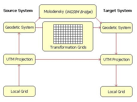
While the Universal Transverse Mercator (UTM) projection is shown as the basis for defining projected coordinate systems, other implementations of Transverse Mercator are also supported.
The actual route followed will depend on the degree of similarity between the two systems. As a further option, the availability of transformation grids (block shifts) may determine the method used to convert between two geodetic datums.
Micromine Geobank will automatically determine the best available route for a given transformation and will report the details of the conversion route along with the results.
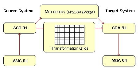
This process can be illustrated by using an example from the Australian context, where it may be necessary to convert legacy data from the old AMG84 map grid to the new MGA94 map grid:
- First, Micromine Geobank converts the projected coordinates from AMG84 to AGD84, and then examines the extents of the available transformation grids to determine whether a suitable grid is available.
- If a suitable grid is available, the conversion from AGD84 to GDA94 is achieved using a simple block shift.
- If no distortion parameters are available for the target area, Micromine Geobank resorts to using the Molodensky formulae for the datum conversion.
- Finally, the geodetic coordinates are projected to MGA94.
Geodetic conversions based on transformation grids provide a greater degree of accuracy than the Molodensky formulae. Results obtained from the latter are acceptable for display purposes, but should not be used in applications where a high degree of accuracy is required. It should also be noted that the Molodensky formulae require ellipsoidal heights in order to perform height datum conversions. However, due to the difficulty in obtaining accurate geoid-spheroid separation values for a given point, the height component is often ignored.