Tools
Locate the Tools button in the top right corner of the Layers panel. It is used to perform various actions with the imported layers. The options, available from its drop-down are described below.

Layers > Tools > dropdown options
Export Layer
You can export single and multiple layers. See the instructions in the table below.

Exporting Layers tool
|
Export Single Layer |
Export Multiple layers |
|---|---|
|
Select one layer you wish to export and in Save As window specify its name, saving path and format (“00t”, “.dtm”, “.dxf”, “.csv”, “.obj” and “.tridb”). |
Select one folder or use <CTRL> and <SHIFT> keys to select multiple layers you wish to export. When exporting multiple, the program allows you to place them into zip file (folder icon in the Export Location field). |
|
Specify applicable format for Construction Line, Solid and any Text what you may have loaded as well. Available formats include “.arch_d”, “.str”, “.dxt”, “.obj”, “.shp”, “00t”. |
|

Export Layers configuration window
Consolidate
Allows to consolidate multiple layers into one. Choose layers required and select “Consolidate” option from the Tools button drop-down. Selected files will be merged into one new generated layer, which contains the consolidated items.

New generated layer after consolidation
Triangulate
The Triangulation function is used to triangulate lines, available only when a polylines file is imported, otherwise this option is greyed out.

Triangulating Layers tool
Translate
Translation function is used to shift information in X, Y and Z-directions if you need a slight change or if you wish to change grids. Translated files will be automatically added to the same folder where original layer is stored.

Translated file is automatically named after original one and followed by “[Translated]”
Decimate
The Decimation function automatically runs when a triangulated file is imported into the software.

Decimating Layers tool
If you didn’t decimate a larger surface when importing it, you still can decimate it using “Decimate” drop-down option. Select a file, choose the level of decimation required (including <None>) and this function will re-triangulate the given layer at a lower resolution. On completion the results will be displayed, and the user has the option whether to use the original data or the decimated.
More details on Decimation function and its benefits see in the Layers/Overlays Panel > Decimation section.
Report Volume
Report Volume is an option to display total volumes of closed solids from layers in the Layers panel.

Reporting Volume tool
-
Select layers you wish to report volumes of.
-
Press Tools button and select “Report Volume” option.
-
Review Volume Report that opens, where you’ll see volumes of selected closed solids and their Total.

Volume Report
Create Final Surface
“Create Final Surface” function is more orientated towards Spatial Conformetrics module. See: Final Surface Tool
Collapse All and Expand All
The last two drop-down options are used to collapse and to extend all folders. It is particularly useful when working with larger projects with multiple layers, organised in many folders and subfolders.
|
|
|


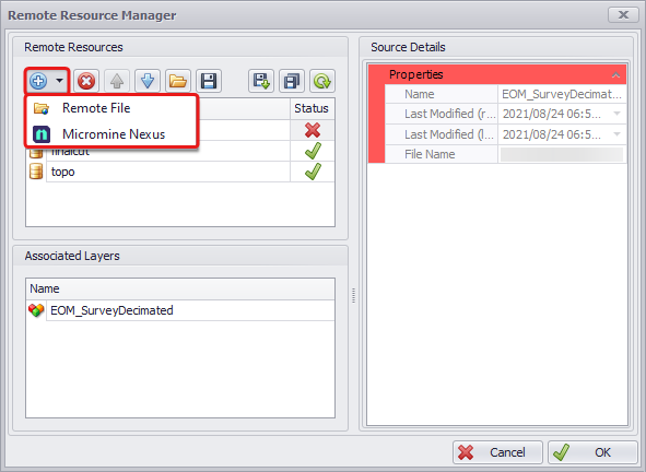
Manage Remote Layers
In the most recent releases of the software (starting from version 22.3), a new Manage Remote Layer tool has been added to make it easier to share files with surfaces and surveys. With this tool, you can specify the path to files stored on the network that are available for use by multiple users and updated periodically.

Manage Remote Layers tool
-
Open the Remote Resource Manager dialog and add files stored remotely on a shared Network or/and in the Micromine Nexus. The added files will be listed in the Remote Resources section of the dialog and displayed in bold green in the Layers panel.
-
Once you add a file from a remote resource, it will be stored in the project as a layer and displayed in the Layers panel as a folder with an associated layer. Note that remote layers cannot be renamed or deleted from the Layers panel.

Remote Resources Manager and Layers
-
Click theRefresh button to update the Remote Resources. Changes made to remotely stored files will be communicated via warning signs, such as red cross and yellow triangle.
-
The Source Details panel on the right stores data on each remote file, such as Name, Last Modifications (remote and local) and File Name showing the file location on the network.
-
You can also Export Remote Mapping using the floppy disk icon in the top toolbar. It will generate a “.rfm” file listing each remote resource location. This mapping you can further import to another project using the Import Remote Mapping icon.

Importing and Exporting Remote Resource mappings
-
In the Associated Layers panel see the layers associated with each of the imported remote resources.